The drive along the Windward coast of St Vincent is an interesting one.
Definitely less hilly than along the Leeward coast it nevertheless has some
hills and numerous turns. Along the way you pass through many small villages
and some of St Vincent’s banana plantations.
At one period in St Vincent's history, bananas dominated the island and
was the main economic activity. A combination of hurricanes, volcanic
eruptions and low prices hurt the industry in St Vincent. In 1980 Hurricane
Allen which eventually became a category 5 hurricane passed through the
Windward islands and although a category 3 at the time it devastated St
Vincent and the banana production. In 1987 Hurricane Emily passed through
the Caribbean with the eye of the storm passing directly over St Vincent and
wiping out 70% of the banana production. Bananas continue to be the leading
export product from St Vincent and a major source of foreign exchange and it
is estimated to account for close to sixty percent of employment. However
the low prices on the world market affects the industry so the banana
plantations are not as extensive as in the past.
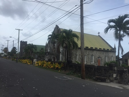
Towards the end of the Windward Road you enter Georgetown which bears the
same name as the capital of Guyana. Georgetown is the former capital of St
Vincent and the second largest town. However it is a small town with
approximately 1,700 inhabitants. One interesting feature of Georgetown is
the religious tolerance that must have existed in the 1700's. Along the main
street in the center of the town you find the Methodist, Anglican and
Catholic churches clustered together with the present Anglican church having
been rebuilt in 1843.
Just beyond Georgetown is the Rabacca Dry River and if you stop to look
at the river you see how wide the river is. It is said that up in the
mountains many streams flow down but at some point they go underground
resulting in the Dry River. However at times huge flows of water come all
the way to the sea and then the river is not dry at the point where the road
crosses.
Immediately after the Rabacca Dry River is the start of the La Soufriere
hiking trail. Carrying the same name as the volcano in
St Lucia, La
Soufriere is a 4,000 foot active volcano. In 1902, the La Soufričre volcano
erupted, killing 2,000 people and destroying the surrounding farmland. In
April 1979, the volcano erupted again and there was extensive damage to the
agricultural plantations but no loss of life. This mountain occupies almost
the entire northern third of the island. You can drive part of the way along
the trail in a 4 wheel drive vehicle and then park to start the hike which
is 3 1/2 miles and estimated at two hours. The hike from this side of the
volcano is said to be easier than the western approach which is 6 miles
longer and rougher.
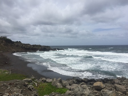
The best reason for driving along the Windward coast however are the
dramatic ocean views that are seen from the road. Be forewarned however that
the roads in St Vincent are narrow so you have to look for a good location
if you want to pull aside and take photos.